Saturday, June 27, 2015

Heading South

The forecast for Tuesday didn't sound too good. The remnants from Hurricane Bill was heading our way and some severe weather was expected. We were not sure exactly what that meant but we felt that we should make tracks to get out of the storms way. So we starting moving south in a westerly direction.


We soon were out of Maine and decided to skirt around Boston, Philadelphia and Washington. So we
drove through Massachusetts and continued into Connecticut. Looking through the RV Travel Guide we picked out a park that indicated that it was just off the Interstate - it just didn't say how far. Anyway we wound up here at Wilderness Lake RV Campground. Not bad for an over night - that's the lake through the trees - specially with the two thunder storms that passed over us. Fortunately just rain, lightning and thunder with no damage.

That was Tuesday night. We got up early on Wednesday and continued through New York and into Pennsylvania. Looking for a overnight stop near Carlisle the lady in the GPS was messing with us again. We turned on three or four country roads and we finally decided that there was no park where we where and that we were not lost, just disoriented. We stopped in a cleared area on the side of the road and now the GPS was in a dumb spot and we were unable to communicated with the nice lady. Susan wanted to get out of here since there was nothing around and we had seen just a few buildings and no people for quite a while. She likes syfy programs and I know she was thinking zombies. We made a 180 and tried to backtrack the roads that we had been on. One road looked promising so we figured it would take us somewhere and then we would know where we were. It did and after a few miles we saw the name Carlisle on the water tower.  Out came the book, the lady was back and we plugged in Western Village which was close to  us and just a mile and a half off of I-81. It was a nice park with nice RVers and one really nice dog that Shadow played with.


Thursday, after a super good breakfast at the local diner we got on the road and soon were in Virginia. I-8l weaves through the Shenandoah Valley and is a very scenic highway. Granted that there are more 18 wheelers on the road than there are cars you still get to see see the mountains and, oh yes, get a little rain on the wind shield.


Anyone know where the Pink Cadillac Diner is? This is Virginia's tribute to Elvis Presley. We stopped here for dinner before we drove across the street to the KOA campground for the night. Maybe 6 or 7 years ago on a motorcycle trip with some of my buddies we stayed at this motel and ate both dinner and breakfast at the diner. No, they didn't remember me.

OK, OK, it's in Natural Bridge, VA.

Friday, more of the same - I-81, 77 and 40 and here we are in Marion, NC at Tom Johnson's RV Sales and Campground. And yes, we may be looking for an RV with an island bed and a little more room inside.




Tuesday, June 23, 2015

On thee Road Again

On Thursday we drove into Old Orchard Beach and up to the Wild Acres RV Resort, maybe the nicest campground that we will visit on our trip. First of all the streets are all paved which means no dust, dirt or gravel. The place is huge, maybe 90 acres and contains cottages, both park model homes and sites that can be rented or purchased. There all all kinds of travel trailers, 5th wheels, pop ups and many people camping in tents. They also have several play areas for kids plus pickle ball courts, horse shoes and shuffleboard, really a complete campground with different activities on the weekends. We took a walk around the park and there were several campers with dogs. One of the campers told us that there was a PetsMart at a shopping center off of I-95 one exit down in Biddeford. We called and were able to get an appointment for Shadow on Friday.


In the afternoon I walked though the park and out the rear entrance to the beach. The pier in the distance is in the middle of town, It's low tide and those are rocks that guy is looking at.

Friday we took Shadow to the groomer for a bath, brush out and nail trim. While at the center we enjoyed lunch at Panera and did some shopping at the market. On the way home one of the dreaded lights on the dash came on - it was the engine diagnostic light. Back at the park we found that there was a M-B dealer in Saco, the next town north, about a 20 minute away. I called and was told that Saturday and Monday were out and maybe we could get in on Tuesday. We figured that we would show up on Monday and see if they could works in.


Ever since Susan's daughter, Deva, has lived in FB she has taken me out for breakfast on Father's Day. This year was no exception except she wasn't with us. Father's Day is on Sunday but I was judging a BBQ contest on Sunday and don't eat breakfast before the contest. Susan and I walked to Java Joe's which was right next to the campground. The sky was blue, the sun was out and the temperature was climbing up to the mid 70's. We had a great breakfast. Thank you, Deva


On Saturday the City trolley started running and on of the stops was in the park. The trolley makes a loop around the town with several stops every half hour and costs a dollar. We caught the trolley and rode down to the center of town where all the action was. This is the pier that is absolutely wild - apparently it's privately owned and there are many little shops for everything you think of all the way out to the restaurant at the end of the pier. Even the restrooms cost 50 cents to use.


This is what goes on at the beach. Main St. is a divided street with shops and food vendors on both sides of the street. There is also a huge amusement part with every type of ride that you can imagine. The beach and streets were packed with people and I'm glad we'e leaving before the "season" starts.

The Maine Championship BBQ contest and car show was scheduled for Sunday. Unfortunately the remnants of Hurricane Bill passed over and it rained all day. The car show was a bust but the BBQ contest goes on rain or shine. And it produced some very good Que. Susan didn't to cook tonight.

Monday we spent most of the day at the M-B dealership and whatever was wrong was fixed. We don't like the mechanical problems but the M-B dealers all have a very nice customer lounge with coffee, drinks and pastries. Not to shabby.

So now it's Tuesday we we are ready to hit the road. Shadow has had his lap around the park and I'm walking over to JJ's for two breakfast sandwiches.

Destination - Somewhere in CT.


Friday, June 19, 2015

Old Orchard Beach

Our goal today was to drive from the campground in Phippsburg to Old Orchard Beach where we are staying for three nights for a little R & R plus judging a KCBS BBQ contest on Sunday. Our return list was now down to Just two items. They are a return visit to J Jill in Kittery and our final knit shop stop in York which on the way up we couldn't find because we thought it was in Kittery, too. Our initial plan was to make those stops after OOB because they are on the way but plans never are set in concrete.

Since we got started early we decided to knock them off the list and then drive back up to Old Orchard Beach. That's done and there wasn't anything worthwhile for pictures so this blog is done, too.

Thursday, June 18, 2015

Rockport

Just after Camden we made a second visit to the huge, two level Maine Sports Outfitters. We had stopped there before but obviously there were a couple of items that both had missed. Afterwards we located our campground in Rockport - the office was closed when we arrived and we left before it opened in the morning. So on the way out we left $40 in an envelope, wrote thanks and left our phone number.


In Rockland we visited the Farnsworth Art Museum. On our trip up the museum was closed for renovations and so it was put on our list for the return home. Along with MAINE in America and CONTEMPORARY Maine the museum is home to the wonderful WYETH FAMILY in Maine exhibit. Showcasing works from three generations of this family of American art, the Wyeth Center offers visitors a comprehensive survey of the Maine related work of N. C. Wyeth, his son Andrew and Andrew's so, Jamie. N. C. Wyeth was the foremost illustrator of his time, whose work enriched children's classics such as Treasure Island and Robinson Crusoe.

Since we were retracing our trip Susan felt a need to revisit the knit shop in Damariscotta and a little shop in Wiscasset where she wanted to buy another hair clip. On a previous blog was a picture of Red's Eats where the lobster roll contains more than a whole lobster. 


We didn't sample one then but we did yesterday along with a couple of crab cakes. Some kind of good!  Just in case, those are Farnsworth stickers on our shirts.


On Hwy US 1

I forgot to mention that the first stop on our return trip was just a few miles from Calais - the International Historic Site, Saint Croix Island. This is where Pierre Dugua was commissioned by King Henri IV to establish a French settlement. Arriving in April 1604 the 79 settlers began building but after 35 deaths in the harsh winter the remaining men, after the supply ships returned, moved back to Port Royal on Nova Scotia. There is a wonderful trail down to the banks of the river with some interpretive panels and several bronze statues to tell the story. Unfortunately, my iPhone/camera was back in the RV.


Right after driving through Bucksport our next stop was at Fort Knox State Historic Site, America's first Fort Knox. This was the first and largest granite fort built in Maine. It was built to protect the Penobscot River valley from navel attack with construction started in 1844. Similar to Fort Clinch the construction finally stopped in 1869, the fort was still not completely finished. This picture is from the upper level of the interior. This is a massive structure with batteries both inside and outside of the fort.


This is the entrance in the front of the fort facing the Penobscot River.


This is the new bridge across the river which is similar the the Dames Point Bridge except that the supporting cables are in the center and the traffic lanes are on either side of the cables. Another difference is that the tower to the right is the home of the Tallest Public Bridge Observatory in the World - 420 feet tall. Susan and I rode the elevator up and I enjoyed the view especially looking down at our teeny, weeny RV. I'm not sure if Susan opened her eyes at all.


Wednesday, June 17, 2015

Back in the US of A

So now we dug out our list of items that we skipped or missed and that we wanted to see on the trip home. Our first stop on Monday was Eastport, ME to pickup our mail and to have lunch with Sally and Big Ed Emery, parents of the wife of my youngest son, Jeff. We warned them that we were on the way but they still invited us over to their house where Sally fixed Crab rolls that were just wonderful.


There we are - that's the four of  us.


Some public sculpture in Eastport. This used to be a big fishing town until the sardines were all fished out. The downtown has some nice shops and restaurants. They are working on building a new wharf that will be able to handle some of the cruise ships that ply the northern waters.

This fisherman statue was on the waterfront when Susan and I were in Eastport 20 years ago when Jeff and Ann Margaret were married.

After Eastport we drove down to Lubec where Susan had missed a knit shop. While she was shopping Shadow and I found  beach and I was able to fill my pockets with sea glass.

Last day in Canada

After Hopewell Cape we drove down the coast through the Fundy National Park to St John. Funny the Fundy Park was a nice drive but the road was inland and we never saw the coast. At St. John we stopped at Reverse Falls and either we were 6 hours too early or 6 hours too late. The tide, unfortunately, was going out and all we saw was rapids. On an incoming tide the amount of water coming in is so strong it makes the rapid like a "reverse falls" or something like that. Anyway, we wound up , that evening, at one of our favorite Canadian places - St Andrews - and back at the Kiwanis Oceanfront Campground.

Sunday in St Andrews was their Art-rageous Festival, one of their biggest events of the year. The site was the Kingsbrae Gardens and the even included their highly acclaimed annual sculpture competition. There was a farmer's market and some craft and food vendors as well as art workshops for children from the area schools. Included in gardens is a beautiful Gardens Cafe in the turn of the century Edward Maxwell manor home original to the estate that makes up the bulk of the garden's 27 acres.


The feature event of the Festival was a concert by the Sistema Childrens Orchestra from St John. Sistema, originated in Venezuela and now adopted by New Bruswick is a program which provides instruments and after school music lessons for underprivileged children starting in the first grade.


St Andrews has always been a resort town and here's one of their grand structures. The Algonquin Hotel opened in June 1889. The Loyalist residents of St. Andrews helped to develop the summer tourism that the hotel was creating among residents of humid inland cities of North America.
One of The Algonquin's best known attractions was its saltwater baths. Saltwater was pumped from Passamaquoddy Bay to the hotel atop the hill overlooking St. Andrews and held in water tanks in the hotel attic. Guests used bathtubs designed with four taps, two for fresh water and two for saltwater.

After the concert we packed up and crossed the border back to Calais, ME.


Friday, June 12, 2015

Hopewell Cape


This is the light at the Cape Jourimain National Wildlife Area  on the New Brunswick side of the bridge. We stopped at the New Brunswick Welcome Center and the agent gave us a map for our route through Moncton to our destination of Hopewell Cape. The Ponderosa Pines campground is very close to The Rocks Provincial Park where we wanted to view the rise and fall of the Bay of Fundy tide.


This is looking down from the top of the stairs at the rock called Flower Pot. The beach is red sand, almost like Georgia clay, and the water is almost the same color. Those are real people on the beach. The time is right at 11:30 about an hour before dead low tide. Susan and I walked down to the beach and unfortunately brought Shadow with us. Oh, he had a ball running around the beach and playing in the mud but he was skittish about walking up the stairs so I carried him and I wound up covered in red mud. At the upper landing there were water hoses to wash off your shoes so I was able to give Shadow a spritz bath and wound up getting wet in addition to the mud.


This is the same Flower pot in the evening about two before high tide. The stairs have been closed and the beach is completely covered with the water is way up the side of the cliff. I'm estimating the tide is 35 feet at that time and don't know the final number.

We stayed in the park two nights and a funny thing happened while there. On the back of our RV there is a large Gator (UF) decal. The next day here comes a truck pulling an Airstream trailer with the same decal on its window and parks right next to us. They were from Tampa and naturally we had to talk a little Gator smack.


Wednesday, June 10, 2015

Bye, Bye PEI

Some people we had met on the road told us about a nice campground in Darnley so we were heading there after leaving Cavendish. Now the road maps we are using, I think, are printed by some joker in the department of tourism. Some of the numbers of the roads are missing and some of the roads aren't exactly where they are shown. Fortunately the towns are close together and the scale is is in kilometers which is smaller then miles. They other funny thing is that the road signs are way before the turns and then the road to turn on has no markings. What I'm getting at is that we missed a few roads and I've vastly improved my technique for making both U turns an 3 point turn arounds.

After a few of those we went though the little town of New London with it's couple of restaurants which reminded me that it was time for lunch. We don't go back (unless we have to). The good news is that a couple of clicks later we slowed for a bridge and spotted a nice looking restaurant which both agreed was the right  Great decision! One of the best meals that we have had. We both had a cup of seafood chowder which was wonderful - I had an oyster po'boy and Susan ordered two pounds of mussels which I had to help her finish. Can't wait to give Sou'East Bar and Grill a raving good review on Trip Advisor.

Now for the park. It was on both sides of the highway with beaches on either side of the park. There were over 600 sites - most were seasonal and most were empty, Recreational vehicles on the site but no people. Because the park was so large and also pretty far out in the boondocks they had, in addition to the normal amenities, a cafe, convenience store, small theatre, almost everything except for a gas station.

Yesterday we left Darnley and were going to spend the night  at another KOA before leaving the island. It was still early when we got there and so we decided to move on. Our last stop before leaving PEI was at Josie's Knit Shop just a few miles before the bridge.

Now there is no charge to enter PEI either by the ferry or over the bridge but you have to pay to get off the island. This is the last lighthouse before leaving.

By the way I'm calling our time on PEI as Tour d'Knit Shop.


There it is - 8 mile long Confederation Bridge, $36.50 and we're off PEI and back to New Brunswick.


On to Cavendish


I fotgot to put this in the Charlottetown blog. A picture of part of their very nice harbor. It was Sunday and we were able to park in a lot on the waterfront right across the street from a high rise hotel that was connected to their convention venter.

The next day after Charlottetown we drove up to the north coast of PEI to Cavendish. It's not really a town or even a village but the area is billed as THE vacation spot on PEI. There's a golf course (maybe two), a beautiful beach and several small resorts. There's also recreation ares for kids so the place seems to me to be a roadside, mini Disney World.


This is at the entrance to Prince Edward Island National Park, Cavendish, on of two NP's that cover  more than half of the PEI north shore.

 
This beach goes on for miles. Susan waited for me while I walked the shore line looking for, not shark's teeth, but sea glass. Not completely skunked, I found three pieces, two brown and one white, two new and one old.

We stayed in a very nice KOA campground with off season rates, one of maybe ten campers in a 200+ site park.


Charlottetown


The City of Charlottetown is a flourishing community of over 34,500 people located on the south shore of Prince Edward Island. Charlottetown is both the capital city of PEI and the largest city on the island. First settled by the French in 1720 it was not incorporated until 1855. Most of the brick or stone buildings that we saw were built in the late 1800's. These two were built in 1890. With that name you must know that Susan is checking out the Northern Watter Knit Wear.


These are some of the older frame buildings on a side street that house local artist's studios and galleries ,antique shops and cafes. There is a wonderful variety of private and public buildings.


From a distance I thought I was seeing David Levy Yulee but when I got closer and read the description I found out that Shadow and I were talking to Sir John Macdonald who was the first Prime Minister of PEI. We couldn't talk that guy next to me into letting us have the bench for the picture.


Sorry about the shadows and part of my finger over the lens but I just had to take the picture. Charlottetown has several very nice pieces of public art. The US has it's Eagle and Canada has it's Loon. The Canadian money system doesn't have any one dollar bills - They have both a dollar coin and a two dollar coin. An image of a loon is on the backside of the dollar coin so it is called a Loonie. The two dollar coin is larger and is called a Toonie. So say hello to the Loon, The Canadian national bird.


Monday, June 8, 2015

Prince Edward Island

PEI, how did we get here? Well, we left Peggy's Cove heading to Cape Breton and because it was shorter chose the middle road which may have been a big mistake. We bypassed Halifax and turned north at Truro. The road narrowed from 4 lanes to 2 lanes and became very hilly, like 40 MPH up the hills and 60 MPH down the hill. Not too much fun. We still had a long way to go and after driving the Cabot trail we would be driving back on this same road. We started talking about the rain days we lost and the extra days we had spent in some places and realized that our timing was off. So we made an executive decision - to take the ferry to PEI and forego Cape Breton for another trip. The worst part was missing a yarn shop in Baddeck which is supposed to be quite nice.


There we are on the ferry for a 75 minute ride to PEI. The top loading level is for cars and the lower level is for whatever else,  RV's, trucks and tractor trailers. No one is checking that weight and I'm thinking mishaps in 3rd world countries. The ferry is free to get on the island but there is a charge when leaving by the ferry or the bridge.


We had a choice to leave Shadow in the RV or take him to the upper deck, not inside, but outside which was sunny and warm when we got to the tables at the back of the lounge and out of the wind. Not sure where these lighthouses are - most be some island but I can't find it on the map.


As the ferry docked the there was Woods Island lighthouse which is located in Northumberland Provincial Park. We stopped at he nearby Visitor Center, got maps and information for lunch and here towards the town of Souris.


After a great lunch at #5,  a restaurant in Murray River that is in an old church building we continued driving north. The gallery, Artists on Main, in Montague wasn't open but right across the street in their riverfront park was this wonderful public sculpture.


We spent the night in Brudenell River Provincial Park, the nicest government park that we have stayed in both in the States and in Canada - full hookups, low density, a pool, beach, hiking trails and horses in the season - this was like a real resort. And it started raining.

The rain was fairly light, not enough to make us stay in the park all day so we drove up to Souris.
A lot of our friends know that Susan lived on a sailboat in the Caribbean for 10 years BL (Before Lou). For 9 of those years the boat she lived on was named SOURIS. That's French for mouse and named after the previous owner's wife who was nicknamed Mousey. If I'm not mistaken in Yiddish it means Headache. Apparently the town, at one time, also had a few mice running around.

Souris is known for finding sea glass on the beach but it was still raining and a mid tide and a short walk on the beach produced nothing. The rain wasn't going to stop us so we headed to Charlottetown.


Sunday, June 7, 2015

Commments on the blog

For some reason any comments on the blog are coming from texts or emails and not from the blog. Here are the three comments, so far.

1. I talk about knit shops instead of yarn shops. Comment taken - from now on they are Yarn Shops.

2. All the pictures are of things and no people.  I'll add some people pictures when I can.

3. In the Peggy's Cove blog I forgot to mention the memorials for Swissair 111. A good photographer always carries his camera almost like another appendage to his body. All my pictures are taken with an iPhone 6 which, half the time, I forget to carry when I leave the RV. It's also used for GPS in the states. I also don't take enough pictures, dumping the bad ones and keeping the good ones. When we visited the Peggy's Cove memorial I left the phone in the RV so I didn't have pictures to show.

So here's the short short story. On September 2, 1998, Swissair Flight 111 crashed in the ocean at the mouth of St. Margarets Bay, approximately 8 km from both Peggy's Cove and Bayswater. All of the crew and the passengers, a total of 229, perished in the crash. Fishermen from both communities helped in the search and rescue operation.  The remains of the people who died in he crash are buried in Bayswater.

Two Memorials were built, one in Bayswater and the other just a few km from Peggy's Cove in a place called Whales Back. Whales Back, Bayswater and the crash site; make a triangular shape across St. Margaret's Bay, which is reflected in the design of the memorials. Bayswater Beach is at the western tip of the triangle. As you stand at the monument, facing the ocean, the line on your left is the sight line to Whales back. The line to your right leads to the crash site, which lies on the horizon of St.Margarets Bay.The memorial has similar features - sight lines both to the memorial in Bayswater  and to the crash site. 

Friday, June 5, 2015

Lunenburg and Peggy's Cove

It was raining when we arrived in Lunenburg, it rained all night long and all the next day and night. It was too junky to go out sightseeing so we stayed in the RV - Susan read her magazines and books and I mostly played with the computer, except when I had to take Shadow out to do his thing. Shadow had a little fleece for warmth and a yellow slicker that was waterproof. I'm not sure how he got his leg up. I wore a rain jacket (LLBean) and jeans which got wet every time we went out.


Finally, the rain let up and we are able to walk to the "Old Town". What a sight -  colorful buildings and lots of shops and restaurants. Susan was able to do a little damage to our credit card which exchanges at par.


Very interesting. We've visited a lot of working seaport towns and they all have some type of Fishermen's Memorial to honor those who have been lost at sea. Lunenburg is no exception with this beautiful display.


This is the Bluenose II, a replica of the original ship that was built in Lunenburg and lost back in the 60's off the coast of Haiti. Lunenburg has a large working waterfront with several boatyards doing repairs on the large boats that fish 100 - 150 miles offshore.


This part of the coast is a lot like Maine in that it has a lot of peninsulas off the coast and there is a scenic route to these areas. Peggy's Cove was just a few miles away - a very small picturesque fishing village with a short drive up and down some hills to the lighthouse. I hid behind this boulder to take a picture with no people in in. In our short visit there were several tour buses bringing people from Halifax which is only 35 km away.


This is the Peggy's Cove memorial to the lost fishermen. On the right is the working fishermen. in the center is Peggy and friends enjoying the bounty an d on the left is an angel saying a prayer as the fishermen go to see. Quite a monument carved by a 70 year old artist. This monument is right across from the welcome center where we parked and walked past the scattered homes, galleries and wharfs to the lighthouse.

The short story is that one night many years ago a violent storm came up and a sailing schooner got caught in the storm and capsized losing all of the passenger's and crew except for one. A little girl was carried by the current to this cove and found the next morning by people living in the area. Her name was Peggy and she was raised by those who found her and they named the coast Peggy's Cove.


This building is typical of others built over the water. Some are built on pilings and others are built over a wooden structure that is filled with rocks and stones. This is called "crib" construction.

And now we're off for Cape Breton.


Tuesday, June 2, 2015

On the way to Lunenberg, NS

It started raining the night we got to Annapolis Royal - not real hard but in light bands and, you know how it goes. We thought it might bring on a T storm and move on but no, well, then it was some type of front and move on, but no. On Sunday we visited the village in the rain, it was raining when we unhooked the power on Monday and it rained the entire day as we drove around the southern tip (may be eastern, I'm not sure which) of NS and then up to Lunenburg, which as much as we could see, in the rain, looks like a wonderful old historic town to do some exploring.

Here was the game plan - we could take Rt 8 over the hills to the other coast in a couple of hours or we could drive around on the coast  on the country road and visit all the little French villages on the way to Yarmouth. Have lunch and then the coast becomes a lot like that of Maine with the main road inland and lots of roads out to the different peninsulas.


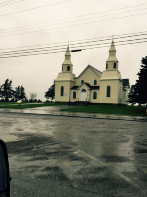
As you can see by the picture we chose the French villages thinking that we might be able to stop at a local Cafe for breakfast. No such luck. These villages were so small that most didn't even have a market or gas station, much less a diner. But they did have churches, I mean big churches. This is Eglise Saint-Bernard in the town of St. Bernard. Sign said built in 1919 - 1942, not sure what those dates mean. Hard to tell but that is all stone.


As soon as you leave one village you are in another village with mostly houses on either side of the road, most nicely painted, manicured lawns and hardly any landscaping, This is Musee Saint-Marie Church, built in 1905 and is all wood shingled. Can you tell it's been raining?


Last of the big churches - this is St. Alphonse Church, built in 1921, in the town of what else - Alponse. All of these towns an/or villages had a sign and above the name was the word Clare, which we think may have been the county, and a French flag with a star in the corner. They are very proud of their French ancestry and some homes even had French flags (with the star) in their front yards.


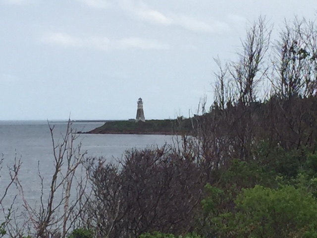
We did visit this lighthouse at Cape St. Mary on a hill overlooking this neat looking harbor. The light appears to be operating although the area was pretty bare and the structure is in need of some TVC. The lobster season just ended in Canada as the season started on May 25th in Maine. These are some of the boats that fish out in Georges Bank as opposed to the Gran Bank which is farther north. It's still a long way off shore.


Here are two happy faces after driving 3 hours in the rain and not stopping for breakfast. We're in Yarmouth at Tim Horton's which about as popular as Duncan Donut's are in New England. We had just finished driving the 325 km Evangeline Scenic Travelway without seeing either Wordsworth or Evangeline and next we're driving the 339 km Lighthouse Scenic Route. Because of the time, rain and distance that we had left to drive we didn't see much of Yarmouth,


This is us on a cable ferry across a fairly narrow river. The boat is only 5 years old and still looked new. It operates 24 hours a day and at night if you are on one side and the ferry is on the other side there is a bell to ring and the ferry will come over to get you. During the crossing the first mate gave me a quick tour below to look at the operating mechanism.


We didn't see any lighthouse but did pass some beautiful harbors filled with fishing boats. Many of the boats had white hulls but some  were painted blue, red, black or green - very colorful. Most of the docks that we saw were built out of wood pilings or beams but this one struck us as very unusual, using big rounds boulders.

We arrived in Lunenburg and after asking direction we found the very attractive campground operated by the Town. It's on the top of Blockhouse Hill next to the Board of Trade (Chamber of Commerce) building. It's still raining, it's still windy and the temperature is between 4 and 8 degrees Celsius - you figure it out. The old town is within walking distance but who wants to walk around in the rain and wind, not us or Shadow. So we're here until the rain stops. We've got everything we need including a couple of TV channels that we can check on the weather in the Canadian Maritime Provinces.